Nepal’s Location: A Himalayan Crossroads
This guide covers everything about where is nepal. Last updated: April 26, 2026
Latest Update (April 2026)
As of early 2026, Nepal is navigating a period of significant political and developmental recalibration. Recent analyses from major news outlets underscore this dynamic. For instance, The Japan Times reported on February 17, 2026, detailing ongoing discussions surrounding the nation’s future trajectory following recent elections. Concurrently, discussions at the Himalayan Futures Forum 2026, as highlighted by Nepali Times on February 5, 2026, emphasize a collective commitment to charting a progressive course for the nation. In parallel, Nepal is actively exploring new avenues for economic growth, with a particular focus on its energy sector. As The Himalayan Times noted on November 17, 2025, there’s a growing emphasis on leveraging solar and advanced storage solutions to meet evolving energy demands and bolster economic development. These developments highlight Nepal’s proactive approach to its geopolitical and economic positioning in 2026.
Nepal’s Precise Location
Nepal, officially the Federal Democratic Republic of Nepal, is a sovereign, landlocked nation strategically positioned in South Asia. Its geographical coordinates place it firmly within the majestic Himalayas, a formidable mountain range forming a significant natural border along its northern frontier. The country stretches approximately 800 kilometers (500 miles) from east to west and varies in width from 150 to 250 kilometers (93 to 155 miles) from north to south. This distinctive elongated shape is a key characteristic of its unique geography.
Answering the question of ‘where is Nepal’ requires understanding its continental placement and its immediate neighbors. Situated within the temperate zone, Nepal experiences pronounced seasonal variations. Its elevation profile is exceptionally dramatic, transitioning from the humid subtropical plains of the Terai region in the south to the perpetually snow-capped, towering peaks of the Himalayas in the north. This extreme topographical diversity profoundly influences its varied climate, rich biodiversity, and the patterns of human settlement across the country.
Nepal: Bordering Countries and Strategic Significance
Nepal shares extensive borders with two of Asia’s most populous and economically significant nations: the People’s Republic of China to the north and India to the south, east, and west. These extensive borders are more than just geographical lines; they represent critical geopolitical and economic relationships that have shaped Nepal’s history and continue to influence its present and future. The border with China extends for approximately 1,414 kilometers (879 miles), largely delineated by the rugged crest of the Himalayas. In contrast, the border with India is considerably longer, stretching over 1,770 kilometers (1,100 miles). This southern border is often more porous, characterized by deep cultural interconnections, open crossings, and substantial cross-border trade and migration.
This unique geopolitical position, nestled between two continental giants, has historically dictated Nepal’s foreign policy and its role in regional dynamics. It has frequently functioned as a buffer state, meticulously maintaining a delicate balance in its relationships with both neighbors to safeguard its sovereignty and national interests. As The Japan Times reported on February 17, 2026, Nepal’s location continues to be a subject of keen interest for its neighbors, impacting its political stability and economic development pathways. Independent analyses suggest that this delicate balancing act requires continuous diplomatic engagement and strategic foresight, as highlighted by ongoing regional dialogues.
Geographical Features: Mountains, Valleys, and Plains
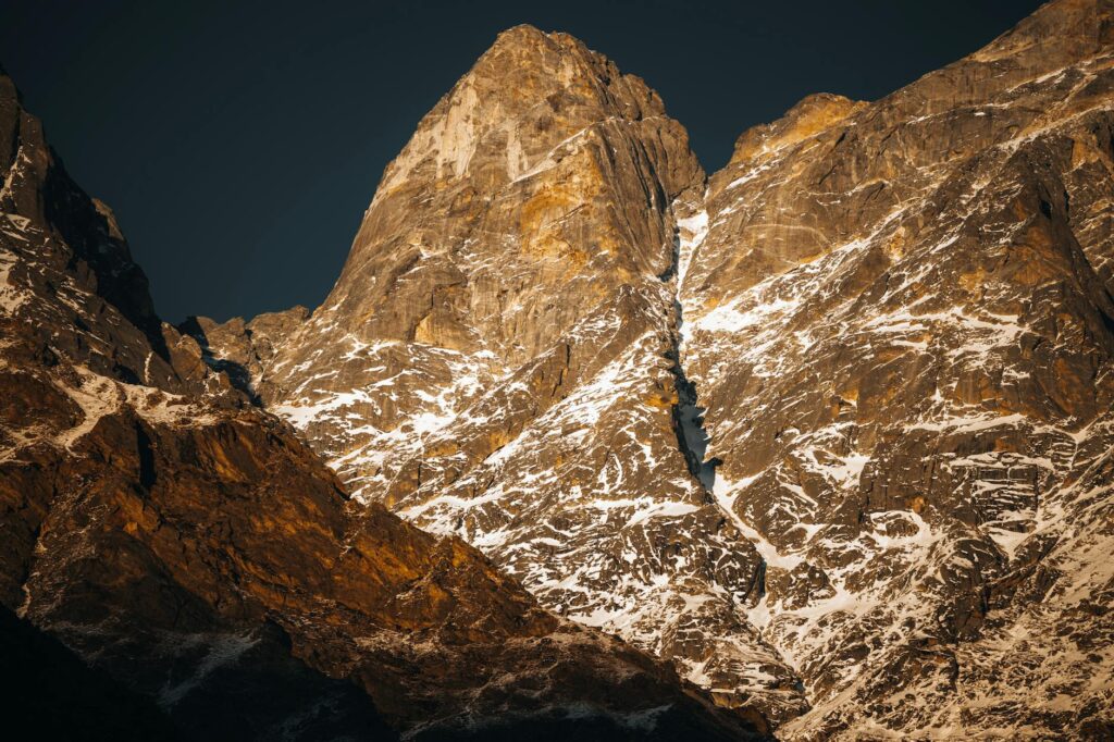
The Himalayas overwhelmingly dominats the geography of Nepal. This mighty range includes eight of the world’s fourteen highest mountains, with Mount Everest (Sagarmatha in Nepali) standing as the undisputed monarch at an awe-inspiring 8,848.86 meters (29,031.7 feet) above sea level, as of the latest measurements confirmed in 2026. This mountainous terrain accounts for roughly 75% of Nepal’s total land area. The dramatic changes in elevation create a mosaic of diverse climatic zones, ranging from arid alpine deserts at the highest altitudes to lush subtropical forests in the lower elevations. Experts note that the geological dynamism of the Himalayas continues to influence Nepal’s topography, with ongoing seismic activity shaping the landscape.
Below the formidable high Himalayas lie the Mahabharat Range and the Siwalik Hills, collectively forming the mid-hills region. This area, characterized by undulating hills and fertile valleys, supports a significant portion of Nepal’s population and is vital for its agricultural output. Prominent valleys within this region include the Kathmandu Valley, the nation’s cultural and political heartland, which historically comprised several independent kingdoms. Further south, Nepal extends into the Terai plains, a fertile alluvial belt that forms part of the larger Indo-Gangetic Plain. This southern region, often referred to as the ‘granary of Nepal,’ is lower in elevation and enjoys a tropical climate, supporting dense population centers and extensive agricultural activities. Reports from the Ministry of Agriculture, Nepal, as of early 2026, indicate that the Terai region remains critical for national food security.
Climate and Biodiversity Zones
Nepal’s diverse topography gives rise to a remarkable spectrum of climatic conditions and associated biodiversity. The northern mountainous regions endure an alpine climate, marked by long, severe winters and brief, cool summers. Temperatures frequently drop well below freezing, and heavy snowfall is common for a significant portion of the year, especially at elevations exceeding 4,000 meters (13,123 feet). This harsh environment supports specialized flora and fauna adapted to extreme cold. Conservation reports from 2025 highlight the vulnerability of these high-altitude ecosystems to climate change.
Transitioning southward, the mid-hills region benefits from a temperate climate, offering warm summers and mild winters. This zone is highly conducive to the cultivation of staple crops such as rice, maize, and millet, forming the backbone of Nepal’s food security. Agricultural studies from the National Agricultural Research Council (NARC) indicate that crop yields in this region are sensitive to rainfall patterns, a factor increasingly influenced by global climate shifts.
A subtropical climate characterizs the southern Terai plains, featuring hot, humid summers and mild, dry winters. This region experiences monsoon rains from June to September, crucial for its agriculture. The Terai is home to dense forests, grasslands, and wetlands, including vital habitats like Chitwan National Park and Bardia National Park, which shelter endangered species such as the Bengal tiger and the one-horned rhinoceros. As of April 2026, conservation efforts in these parks are intensifying, with new initiatives focusing on anti-poaching measures and habitat preservation, supported by international environmental agencies.
Economic Geography and Development Corridors
Nepal’s economic geography is intrinsically linked to its physical location and topography. The mountainous terrain presents significant challenges for infrastructure development and transportation, increasing the cost of goods and limiting internal connectivity. Historically, trade routes have largely followed river valleys and lower passes, connecting communities and facilitating commerce. However, the nation is actively working to overcome these geographical barriers. As of 2026, major infrastructure projects, including highway expansions and tunnel constructions, are underway to improve connectivity between the Terai, the mid-hills, and the mountainous north. These projects aim to foster greater economic integration and reduce regional disparities.
The economic development of Nepal is increasingly focused on specific corridors. The north-south axis, connecting the Terai’s agricultural heartland with the mountain regions and potentially linking to China via northern passes, is a key focus. Similarly, the east-west highway serves as a vital artery for trade and transportation, connecting major cities and economic centers. International development partners, including the World Bank and the Asian Development Bank, continue to fund infrastructure and economic development initiatives in 2026, recognizing Nepal’s strategic importance and its potential for growth, particularly in areas like renewable energy and tourism. Discussions at the Himalayan Futures Forum 2026 specifically addressed the potential of these corridors to stimulate cross-border trade and investment.
Connectivity and Transportation Networks
Connectivity remains a paramount concern for Nepal. Its landlocked status and challenging terrain make efficient transportation networks essential for economic prosperity and national integration. As of April 2026, Nepal’s transportation infrastructure comprises a network of roadways, railways, and air travel. The road network is the most extensive, with the East-West Highway forming the backbone. However, many roads, particularly in the hilly and mountainous regions, are unpaved or susceptible to landslides during the monsoon season, impacting reliability. Independent assessments indicate that ongoing road improvement projects are crucial for sustained economic activity.
Domestic air travel plays a vital role, connecting remote areas and major cities, especially Kathmandu. Tribhuvan International Airport in Kathmandu is the primary gateway for international flights. Nepal is also investing in improving its railway network, primarily in the southern Terai region, to facilitate freight transport, particularly with India. As reported by The Himalayan Times in late 2025, advancements in renewable energy infrastructure, such as solar power installations in remote communities, are also improving local connectivity and quality of life, demonstrating a multi-faceted approach to development.
Cultural and Historical Significance of Nepal’s Location
Nepal’s location has profoundly shaped its rich cultural tapestry and historical development. Situated at the confluence of major civilizational influences from both India and China, Nepal has served as a melting pot of diverse traditions, languages, and religions for centuries. The Kathmandu Valley, a UNESCO World Heritage site, is a testament to this rich history, boasting ancient temples, palaces, and stupas that reflect a unique blend of Hindu and Buddhist art and architecture. This cultural heritage is a significant draw for tourism, a sector Nepal aims to revitalize further in 2026.
The historical interactions along its borders have led to significant cultural exchanges, evident in shared festivals, culinary traditions, and linguistic influences, particularly with India. Simultaneously, the northern border regions exhibit cultural ties with Tibetan Buddhism and Chinese traditions. This cultural mosaic is a defining aspect of Nepal’s identity. As experts in South Asian studies note, understanding Nepal’s location is key to appreciating the nuances of its cultural evolution and its role as a bridge between different Asian traditions.
Environmental Considerations and Climate Change
Nepal’s unique geography, particularly its Himalayan environment, makes it exceptionally vulnerable to the impacts of climate change. Glacial melt in the Himalayas, driven by rising global temperatures, poses a significant threat, not only through potential glacial lake outburst floods (GLOFs) but also by affecting water resources downstream. Studies published in environmental journals in early 2026 highlight accelerated glacial retreat in the Everest region and warn of long-term implications for water availability in South Asia.
The diverse ecosystems, from the Terai’s tropical forests to the alpine zones, are facing increasing pressure. Changes in rainfall patterns, increased frequency of extreme weather events like droughts and floods, and rising temperatures impact agriculture, biodiversity, and human settlements. Nepal is actively engaged in climate adaptation and mitigation strategies. As reported by the Ministry of Forests and Environment, Nepal, in early 2026, the nation is focusing on promoting climate-resilient agriculture, enhancing forest cover, and developing renewable energy sources to reduce its carbon footprint. International collaboration remains vital, with ongoing projects supported by organizations like the United Nations Environment Programme (UNEP) focusing on sustainable development in the face of climate challenges.
Frequently Asked Questions
What are Nepal’s exact geographical coordinates?
Nepal is located in South Asia, roughly between 26° and 30° North latitude and 80° and 88° East longitude. Its territory spans a significant portion of the Himalayas.
Which countries border Nepal?
Nepal shares its borders with the People’s Republic of China to the north and India to the south, east, and west.
Is Nepal landlocked?
Yes, Nepal is a landlocked country, meaning it has no direct access to the sea. Its entire border is with land territories of China and India.
What is the highest point in Nepal?
The highest point in Nepal, and indeed in the world, is Mount Everest (Sagarmatha), with an elevation of 8,848.86 meters (29,031.7 feet) above sea level.
How does Nepal’s location impact its economy?
Nepal’s landlocked location between two large economies, India and China, presents both opportunities and challenges. It necessitates efficient transportation and trade agreements to overcome geographical barriers, while also positioning Nepal to benefit from regional economic integration. As of April 2026, the government is actively pursuing infrastructure development and trade facilitation measures to maximize economic benefits derived from its strategic location.
Conclusion
Nepal’s location in the heart of the Himalayas, nestled between the global powers of China and India, defines its identity, challenges, and opportunities. This unique geopolitical position as a Himalayan crossroads has historically shaped its foreign policy, cultural exchanges, and economic development. As of April 2026, Nepal continues to navigate this complex environment, focusing on enhancing connectivity, fostering economic growth through strategic development corridors, and addressing the profound environmental challenges posed by its mountainous terrain and climate change. Its future hinges on its ability to use its strategic position while maintaining its sovereignty and pursuing sustainable development for its people.
Source: Britannica
Editorial Note: This article was researched and written by the Serlig editorial team. We fact-check our content and update it regularly. For questions or corrections, contact us.